
You Can't Get There From Here
Well, you can - just not very easily….

Fly Geyser, in the Black Rock Desert near Gerlach, Nevada. The geyser is the product of a failed geothermal test well and is located on private land near the Burning Man venue. It’s a long hike from the roadway but access is restricted and must be arranged through The Friends of Black Rock.

The five Big Horn sheep, Grand Canyon. Look close - there are two more down on the left. It was easy to walk here but the timing was nearly impossible.

As we approached the edge of the canyon, the Big Horn sheep started walking up to the edge from below.

I mentioned our encounter to a Ranger and he said that there were only a few hundred sheep within a hundred miles and they always try to avoid humans. He had been there two years and had never seen one.

Crystal Cave, Lava Beds National Monument. Stalactites and stalagmites, but made of ice - and crystals growing from the walls. This frozen wonderland is only accessible by reservation a few months during the winter.

A ranger will guide six people, one Saturday a week on a four hour excursion down and back. No walkways. No lights outside of your flashlights or headlamps. Climb and crawl - it’s not for the couch potato!

Fern Cave, Lava Beds National Monument. This is another limited reservation tour but you get to drive there and all you have to do is climb down a ladder.

Although this collapsed lava tube is in the middle of the high desert, the moisture and temperature levels are constant enough to maintain the “tropical” ferns and moss.

Ancient pictographs adorn the walls but the meaning is lost to a previous Indian tribe.

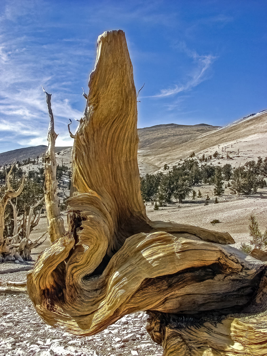
Ancient Bristlecone Pines, Inyo County, California.

Located above 10,000 feet in the White Mountains, these trees have escaped disease and insects for thousands of years.

There is paved road to the Visitor Center but the best specimens are located at the end of “tens miles of bad road” (lost two tires on a Land Rover).

Near the Owens Valley is a high plateau. It’s a long hike on sand and loose rock.

At the top is an ancient petroglyph that is about fifteen feet across.

It has eluded vandalism due to its remote location and deliberate lack of documentation. I searched on and off for ten years until I finally located the coordinates in an obscure journal.

The Crystal Mill in Colorado was built in 1892 as a powerhouse for mining equipment.

It’s located on the Crystal River at the end of only four miles of bad road (only lost one tire this time).

The Wave, Vermillion Cliffs National Monument. The location of this rock formation was a well-guarded secret until National Geographic printed a map in their magazine.

But access is still limited by lottery permits of twenty hikers per day - ten on-line and ten by draw at the local BLM office.

It’s a seven mile round trip hike on slick rock and sand dunes. (That’s about 20 miles in dog years.) It is a serious adventure. Several people have died due to heat or falls.

Angels Landing in Zion National Park is a six hour, five mile round trip hike with a 1500 feet elevation gain. It is a strenuous climb on a paved path for most of the trek. The last half mile is a path carved into the rock with support chains. It’s not for the acrophobic but only five people have fallen off so far.

Spider Rock is located on the Navajo Reservation which is in the middle of Canyon de Chelly National Monument.

Public viewing of the formation is from the upper canyon rim but if you want a view from the ground up you must book a Navajo guide and purchase a travel permit from the reservation. Cash expedites both transactions.

This is an all-day Jeep trip and only a handful of drivers will attempt the trek all the way to the Rock. Our guide, Danny, made a Camel Trophy driver look like an Uber.

I couldn’t get there either - just observe from afar. The Aid To Navigation unit of The U.S. Coast Guard lowered a Guardsman by cable to a light beacon/fog horn structure on a large rock at the mouth of the Albion River. It was the only way to change the light bulb.

Rainbows you can find just about anywhere. A FOGBOW is harder to experience. It is white rather than multi-colored because the droplets are large and reflect rather than refract light. This one was near Old Faithful in Yellowstone National Park in the winter. The steam from the thermal fields condensed with the cold morning air at just the right light angle of the sunrise.

At a lodge in Denali Borough, Alaska, the staff was kind enough to wake us to view the aurora borealis.

Nasa had reported a double solar flare that was the largest in over a decade so we knew that the phenomena was probable.

We didn’t know that the double burst was so intense that it blacked out some communication and would provide a multicolored presentation spanning over a hundred and fifty miles in altitude.

Eminent photographer Dave Henry and Canon USA organised an open-door helicopter tour of the Bay Area by a veteran news pilot. The pilot knew exactly where to fly and at what angle.

I noted to my seatmate that we are at the age where we are shaky on a ladder but we didn’t mind being strapped to the side of a helicopter.

Dave Henry also managed to arrange a private tour of Alcatraz for forty photographers. This would be your view from across the hall if you happened to reside in a second floor cell.

We also had access to the basement of the main building. That area was the military prison when the island was a fort in the 1800’s. Prisoners would write their names on the walls for documentation in case “they never got out”.

The infamous Racetrack in Death Valley National Monument. After many miles of bad road to the “Racetrack” dry lakebed, an additional two-mile hike across the lake led me to a pair of rocks that had traveled side by side. A combination of flash storms in freezing temperatures with high winds nudge the rocks to produce tracks in the clay. The rock on the left had a bit of quartz that refracted the sunlight to project a “headlight” in the shadow.

….THANKS FOR THE LOOK1